NWS National Hurricane Center
Miami, FL
8:00 AM EDT Sat, Sep 21, 2024
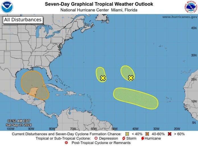
Central Subtropical Atlantic (Remnants of Gordon):
The remnants of Gordon, located over 1,000 miles southwest of the Azores, continue to be affected by strong upper-level winds, keeping showers and thunderstorms displaced. Significant development is not expected as it moves slowly northwestward over the next few days.
- Formation chance through 48 hours: Low, 10%
- Formation chance through 7 days:Low, 10%
Central Subtropical Atlantic (AL96):
An area of low pressure about 700 miles northeast of the northern Leeward Islands is showing disorganized shower and thunderstorm activity. Conditions are not favorable for significant development in the coming days as it drifts northwestward at around 5 mph.
- Formation chance through 48 hours:Low, 10%
- Formation chance through 7 days:Low, 10%
Northwestern Caribbean Sea and Gulf of Mexico:
A broad area of low pressure is expected to form by early to mid-next week over the northwestern Caribbean and nearby Central America. Gradual development is possible, with a tropical depression potentially forming as it moves slowly northward or northwestward. Heavy rains are expected over parts of Central America in the coming days, regardless of development.
- Formation chance through 48 hours: Low, near 0%
- Formation chance through 7 days:Medium, 60%
Eastern and Central Tropical Atlantic:
A tropical wave is forecast to move westward from the African coast on Sunday or Monday. Gradual development is possible next week as it moves west-northwestward over the eastern and central tropical Atlantic.
- Formation chance through 48 hours:Low, near 0%
- Formation chance through 7 days:Low, 30%
Forecaster Berg
